THE ULDALE AND CALDBECK FELLS
|
The Uldale and Caldbeck Fells
are largely rounded and smooth hills cloaked in grass heather and bracken.
They are quite different to the volcanic central area. Despite a lack of
drama in the scenery the extensive views over the Solway Firth to Scotland
are well worth the easy ascent required. Good weather is essential here
because shelter and landmarks are few on the gently contoured ridges. Even
though these fells do not compare with those at the head of Borrowdale, walkers
seeking the peace and solitude earlier visitors might have expected may well
be disappointed. The formation of paths in recent years testifies to the
growing number of people here. The fells are situated north of the lofty
Skiddaw and Blencathra groups, and are often hidden in views from the centre.
However the Uldale Fells peer round Skiddaw towards Whinlatter; the Caldbeck
Fells look east of Blencathra to the Martindale and High Street ranges while
Knott and Great Calva provide a view of Lakeland down the Glenderaterra
Valley to Thirlmere and Derwent Water. Binsey stands apart to the north of
the rest and it's grand view includes them, but the highlight is the scene
down Bassenthwaite Lake to the far Coniston Fells. The road from High Side to
Caldbeck via Orthwaite, Longlands and Fell Side gives access to these hills
as does that through Mungrisdale and the spur into Mosedale. This area can
conveniently be reached from Keswick, but the village of Caldbeck is the best
place for a base to explore this part of the district. The old mines are a
source of interest here, and many of the tracks on the hills are the result
of this industry. Of the fells themselves a special mention must be made of
Carrock Fell, which has unique rocks on its eastern flanks, and a remarkable
hill fort on the summit. There are no tarns on these fells, but Over Water
and Little Tarn lie between the main group and Binsey near Orthwaite. Perhaps
there is a lack of excitement here, but Knott and it's satellites do not
compete with Scafell and Great Gable. They provide fine easy walking in
scenery that soothes the mind, and in the views to the north they cannot be
beaten.
|
|
|
|
|
----------------
|
ROUTE ONE. KNOTT FROM FELL SIDE VIA BRAE FELL AND GREAT SCA FELL.
4 miles. 1550ft of ascent.
|
Ascent Breakdown
|
Distance
|
Ascent
|
|
miles
|
km
|
ft
|
metres
|
|
Fell Side to Brae Fell
|
2.25
|
3.6
|
1050
|
320
|
|
Brae Fell to Great Sca Fell
|
1
|
1.6
|
250
|
76
|
|
Great Sca Fell to Knott
|
0.75
|
1.2
|
250
|
76
|
|
|
|
|
click to enlarge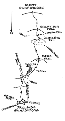
|
The old
mines at Roughton Gill provide thc best approach to Knott, but the pattern of these walks is to
link up subsidiary tops on the way to the main summit. Go up thc valley of Dale
Beck as far as the footbridge, and walk back downstream to the foot of Ramps Gill. The
ravine of the gill is something to look at during the climb to Brae Fell; which provides
little else of note until the large summit cairn is reached. A good path heads
along the ridge and curves up right to thc top of Little Sca Fell. Great Sca Fell is
now close by beyond a slight depression. The path linking Great Sca Fell to Knott
clearly continues ahead with a modest ascent only needed before the expansive top is
gained. A return can be made to Fell Side by following the line of Route Two to
High Pike before descending over Deer Hills
|
|
----------------
|
ROUTE TWO. KNOTT FROM
CALEBRACK VIA HIGH PIKE, GREAT LINGY HILL AND NAMELESS TOP ABOVE IRON CRAG.
4.75 miles. 1675ft of ascent of ascent.
|
Ascent Breakdown
|
Distance
|
Ascent
|
|
miles
|
km
|
ft
|
metres
|
|
Calebrack to High Pike
|
2.5
|
4
|
1150
|
350
|
|
High Pike to Great Lingy Hill
|
1
|
1.6
|
75
|
23
|
|
Great Lingy Hill to Top above Iron Crag
|
0.5
|
0.8
|
50
|
15
|
|
Top above Iron Crag to Knott
|
0.75
|
1.2
|
400
|
122
|
|
|
|
|
click to enlarge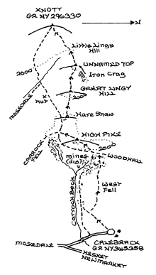
|
The best
route from Calebrack is over West Fell though the track by Carrock Beck
may be followed up
to the top of the old Driggith Mine workings. Either way the broad track coming up from
Wood Hall will be met, and after a few yards along it left take a narrow rising path
on the right which will guide you onto High Pike. After examining the summit
decorations go down the broad south slope to rejoin the big track which is the Cumbria
Way, but on top of the first rise tum off to the nearby cairn on Hare Stones.
Continue in a south westerly direction across a slight depression and ascend the
gentle slope of Great Lingy Hill. Another depression is crossed leading to the
better summit of the nameless top above Iron Crag. There is a nice view from here
down the valley of Dale Beck. A path descends from here towards Thief Gills but
leave it above the stream and strike directly up over untrodden ground to Little
Lingy Hill and Knott. The main track can of course be retained on Hare Stones to
go past the Lingy Hill mountain hut to the crossing of Grainsgill Beck. A good
path now climbs the bank beyond the stream, and continues clearly up the broad ridge
to the extensive summit of Knott. The best route back to Calebrack by far is to
return to Hare Stones, and then at the foot of High Pike turn right along the ridge to
Carrock Fell. Descent is best made using a good path which will be located by turning
north towards Carrock Beck at the foot of the final rise to thc summit.
|
|
----------------
|
ROUTE THREE.KNOTT FROM STONE ENDS VIA CARROCK
FELL.
5.25 miles 2200ft of ascent.To Carrock Fell it is 1 mile 1425ft of
ascent.
|
|
|
|
click to enlarge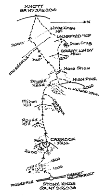
|
Go up Rake Trod which is
clearly in view from the road, and through the breach in the crags to the
upper plateau from where the East cairn and summit are not too far away. Take
time to admire the wall ringing the top and the general situation, for there
will be nothing better to see beyond. A good track follows the somewhat
spongy ridge to the head of Dry Gills where the Cumbria Way and Route Two is
joined. High Pike can very easily be added to the walk here. Turn left along
the track past the Lingy Hill hut and cross Grainsgill Beck onto the ridge
leading to Knott.
|
|
----------------
|
ROUTE FOUR. KNOTT FROM MOSEDALE VIA COOMB HEIGHT.
4 miles 1600ft of ascent. To Coomb Height it is 3 miles 1325ft of
ascent.
|
|
|
|
click to enlarge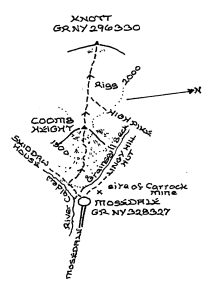
|
Coomb Height rises at the head
of Mosedale where the surfaced road terminates. It is not
blessed with paths, though one of sorts endeavours to ascend the ridge. Take
care on the heathery top as some dangerous old mine workings lurk nearby on
the flanks. Continue ahead to eventually pick up the good path coming up from
the Cumbria Way at Grainsgill Beck; which leads unerringly if rather
squelchily to Knott. As with Route One the finest route of return is over
Carrock Fell; though the descent down the south east shoulder is not the
simplest if unfamiliar.This walk may be started from the road terminus which halves the distance
to Knott
|
|
----------------
|
ROUTE FIVE. KNOTT FROM KESWICK OR THRELKELD VIA
GREAT CALVA.
6.5 miles 2175ft of ascent from the top of Gale Road. 7 miles 2450ft
of ascent from Threlkeld. To Great Calva it is 5 miles 1650ft of ascent and
5.5 miles 1925ft of ascent respectively.
|
|
|
|
click to enlarge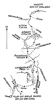
|
From the car park take the
Skidaw path, but below the Hawell memorial bear right along the track to
Skiddaw House. Follow it all the way round the flanks of Lonscale Fell to the
lonely buildings in the heart of Skiddaw Forest; used to telling effect by
Hugh Walpole in his novel 'The Fortress' the third in his Herries saga. The
lane to the Blencathra Centre should be used from Threlkeld continuing beyond
round the fellside to the head of the Glenderaterra Beck, where the other
start route will be joined. Go straight ahead from the house down to the
stream and about 200 yards beyond the footbridge ascend the ridge to Great
Calva. The path is indicated by a cairn, and is continuous though nearly
choked in heather early on. It becomes much clearer as height is gained. A
good path now heads for Knott crossing the ridge fence at a stile before
descending to a deep connecting col with a steepish climb to follow. It makes
for a long day to return to the starting points; so a car in Mosedale or the
Dash Valley to reduce the mileage might be appreciated.
|
|
----------------
|
ROUTE SIX. KNOTT FROM
LONGLANDS VIA LONGLANDS FELL, LOWTHWAITE FELL, BRAE FELL AND GREAT SCA FELL.
4.5miles 1950ft of ascent.
|
Ascent Breakdown
|
Distance
|
Ascent
|
|
miles
|
km
|
ft
|
metres
|
|
Longlands to Longlands Fell.
|
1.25
|
2
|
900
|
274
|
|
Longlands Fell to Lowthwaite Fell.
|
0.5
|
0.8
|
200
|
61
|
|
Lowthwaite Fell to Brae Fell.
|
1
|
1.6
|
350
|
107
|
|
Brae Fell to Great Sca Fell.
|
1
|
1.6
|
250
|
76
|
|
Great Sca Fell to Knott
|
0.75
|
1.2
|
250
|
76
|
|
|
|
|
click to enlarge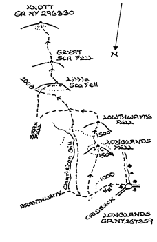
|
From the small parking area by
the waterworks building go through the gate, and take the gently rising track
below the hamlet which leads to Green Head. Turn up the easy ridge of
Longlands Fell and across the depression to Lowthwaite Fell which does have a
tiny cairn hidden in the grass. Now curve round with the aid of a track to
cross the bridleway coming out of Charleton Gill. The track can be followed
all the way to the large cairn on Brae Fell keeping well below the crest of
Little Sca Fell as it does so. The bridleway may be used, but more height and
distance are involved before the ridge path is reached. Return south to the
bridleway and ascend a path up the bank to the right for the cairn on Little
Sca Fell. Finally cross the slight col to Great Sca Fell and Knott on a good
path. A variation return to Longlands may be effected by turning left on
Great Sca Fell for Meal Fell and Trusmadoor, where go right to cross the
infant River Ellen and down by Longlands Beck.
|
|
----------------
|
ROUTE SEVEN. KNOTT
FROM ORTHWAITE VIA GREAT COCKUP, MEAL FELL AND GREAT SCA FELL.
4 miles 2000ft of ascent.
|
Ascent Breakdown
|
Distance
|
Ascemt
|
|
miles
|
km
|
ft
|
metres
|
|
Orthwaite to Great Cockup.
|
1.75
|
2.8
|
1000
|
305
|
|
Great Cockup to Meal Fell.
|
0.75
|
1.2
|
300
|
91
|
|
Meal Fell to Great Sca Fell.
|
0.75
|
1.2
|
450
|
137
|
|
Great Sca Fell to Knott.
|
0.75
|
1.2
|
250
|
76
|
|
|
|
|
click to enlarge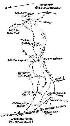
|
A farm
road just north of Horsemoor Hills gives access to the fells. Great Cockup
may be gained by turning up alongside the intake wall and ascending Orthwaite
Bank then keeping to the broad ridge. The alternative is to continue along
the track for a third of a mile to pick up a rising track on the left that
contours above the prominent quartz streaked Brockle Crag.Turn up the
fellside beyond this, and pick a way through the heather to the summit. From
the top there is a good aspect of Skiddaw rising above the scoop of Dead
Crags on Bakestall. Descend east to the col at Trusmadoor which has some
interest, and then follow the recently formed path opposite directly to the
curious top of Meal Fell which boasts a nice wall shelter, and more stones
than most fells hereabouts. Beyond the slight depression take the slanting
path to the left which leads to the ridge between Great and Little Sca Fell.
Turn right to the cairn on Great Sca Fell, and then head south on a good path
to the rising slopes of Knott ahead. The simplest way back is to descend to
the col below Great Calva there turning down into the head of Hause Gill.
|
|
----------------
|
ROUTE EIGHT. BINSEY FROM BINSEY LODGE.
0.75 miles 620ft of ascent.
|
|
|
|
click to enlarge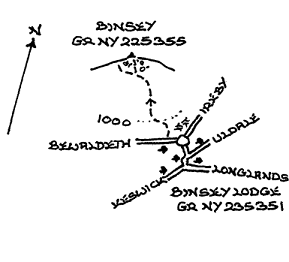
|
Binsey stands apart from the
main block of hills, but has a nice summit and a superb view. For these
reasons it deserves a visit. From the lodge a stile gives access to the open
fell, and a lovely wide path heads purposefully for the top. Should you go
astray here then perhaps fellwalking is not for you! Although not shown the
best route to Binsey starts near the Roman Fort at Caermote (just off the
A591) crossing Whittas Park. An interesting old lime kiln can be visited just
above the road. Head for the south east corner of the pasture along a
definite track to a stile accessing the summit area .
|
|
Copyright (C) 2007 B S Baker
������������������������������������������������������������������������������������������������������������������������������������������������������������������������������������������������������������������������������������������������������������������������������������������������������������������������������������������������������������������������������������������������������������������������������������������������������������������������������������������������������������������������������������������������������������������������������������������������������������������������������������������������������������������������������������������������������������������������������������������������������������������������������������������������������������������������������������������������������������������������������������������������������������������������������������������������������������������������������������������������������������������������������������������������������������������������������������������������������������������������������������������������������������������������������������������������������������������������������������������������������������������������������������������������������������������������������������������������������������������������������������������������������������������������������������������������������������������������������������������������������������������������������������������������������������������������������������������������������������������������������������������������������������������������������������������������������������������������������������������������������������������������������������������������������������������������������������������������������������������������������������������������������������������������������������������������������������������������������������������������������������������������������������������������������������������������������������������������������������������������������������������������������������������������������������������������������������������������������������������������������������������������������������������������������������������������������������������������������������������������������������������������������������������������������������������������������������������������������������������������������������������������������������������������������������������������������������������������������������������������������������������������������������������������������������������������������������������������������������������������������������������������������������������������������������������������������������������������������������������������������������������������������������������������������������������������������������������������������������������������������������������������������������������������������������������������������������������������������������������������������������������������������������������������������������������������������������������������������������������������������������������������������������������������������������������������������������������������������������������������������������������������������������������������������������������������������������������������������������������������������������������������������������������������������������������������������������������������������������������������������������������������������������������������������������������������������������������������������������������������������������������������������������������������������������������������������������������������������������������������������������������������������������������������������������������������������������������������������������������������������������������������������������������������������������������������������������������������������������������������������������������������������������������������������������������������������������������������������������������������������������������������������������������������������������������������������������������������������������������������������������������������������������������������������������������������������������������������������������������������������������������������������������������������������������������������������������������������������������������������������������������������������������������������������������������������������������������������������������������������������������������������������������������������������������������������������������������������������������������������������������������������������������������������������������������������������������������������������������������������������������������������������������������������������������������������������������������������������������������������������������������������������������������������������������������������������������������������������������������������������������������������������������������������������������������������������������������������������������������������������������������������������������������������������������������������������������������������������������������������������������������������������������������������������������������������������������������������������������������������������������������������������������������������������������������������������������������������������������������������������������������������������������������������������������������������������������������������������������������������������������������������������������������������������������������������������������������������������������������������������������������������������������������������������������������������������������������������������������������������������������������������������������������������������������������������������������������������������������������������������������������������������������������������������������������������������������������������������������������������������������������������������������������������������������������������������������������������������������������������������������������������������������������������������������������������������������������������������������������������������������������������������������������������������������������������������������������������������������������������������������������������������������������������������������������������������������������������������������������������������������������������������������������������������������������������������������������������������������������������������������������������������������������������������������������������������������������������������������������������������������������������������������������������������������������������������������������������������������������������������������������������������������������������������������������������������������������������������������������������������������������������������������������������������������������������������������������������������������������������������������������������������������������������������������������������������������������������������������������������������������������������������������������������������������������������������������������������������������������������������������������������������������������������������������������������������������������������������������������������������������������������������������������������������������������������������������������������������������������������������������������������������������������������������������������������������������������������������������������������������������������������������������������������������������������������������������������������������������������������������������������������������������������������������������������������������������������������������������������������������������������������������������������������������������������������������������������������������������������������������������������������������������������������������������������������������������������������������������������������������������������������������������������������������������������������������������������������������������������������������������������������������������������������������������������������������������������������������������������������������������������������������������������������������������������������������������������������������������������������������������������������������������������������������������������������������������������������������������������������������������������������������������������������������������������������������������������������������������������������������������������������������������������������������������������������������������������������������������������������������������������������������������������������������������������������������������������������������������������������������������������������������������������������������������������������������������������������������������������������������������������������������������������������������������������������������������������������������������������������������������������������������������������������������������������������������������������������������������������������������������������������������������������������������������������������������������������������������������������������������������������������������������������������������������������������������������������������������������������������������������������������������������������������������������������������������������������������������������������������������������������������������������������������������������������������������������������������������������������������������������������������������������������������������������������������������������������������������������������������������������������������������������������������������������������������������������������������������������������������������������������������������������������������������������������������������������������������������������������������������������������������������������������������������������������������������������������������������������������������������������������������������������������������������������������������������������������������������������������������������������������������������������������������������������������������������������������������������������������������������������������������������������������������������������������������������������������������������������������������������������������������������������������������������������������������������������������������������������������������������������������������������������������������������������������������������������������������������������������������������������������������������������������������������������������������������������������������������������������������������������������������������������������������������������������������������������������������������������������������������������������������������������������������������������������������������������������������������������������������������������������������������������������������������������������������������������������������������������������������������������������������������������������������������������������������������������������������������������������������������������������������������������������������������������������������������������������������������������������������������������������������������������������������������������������������������������������������������������������������������������������������������������������������������������������������������������������������������������������������������������������������������������������������������������������������������������������������������������������������������������������������������������������������������������������������������������������������������������������������������������������������������������������������������������������������������������������������������������������������������������������������������������������������������������������������������������������������������������������������������������������������������������������������������������������������������������������������������������������������������������������������������������������������������������������������������������������������������������������������������������������������������������������������������������������������������������������������������������������������������������������������������������������������������������������������������������������������������������������������������������������������������������������������������������������������������������������������������������������������������������������������������������������������������������������������������������������������������������������������������������������������������������������������������������������������������������������������������������������������������������������������������������������������������������������������������������������������������������������������������������������������������������������������������������������������������������������������������������������������������������������������������������������������������������������������������������������������������������������������������������������������������������������������������������������������������������������������������������������������������������������������������������������������������������������������������������������������������������������������������������������������������������������������������������������������������������������������������������������������������������������������������������������������������������������������������������������������������������������������������������������������������������������������������������������������������������������������������������������������������������������������������������������������������������������������������������������������������������������������������������������������������������������������������������������������������������������������������������������������������������������������������������������������������������������������������������������������������������������������������������������������������������������������������������������������������������������������������������������������������������������������������������������������������������������������������������������������������������������������������������������������������������������������������������������������������������������������������������������������������������������������������������������������������������������������������������������������������������������������������������������������������������������������������������������������������������������������������������������������������������������������������������������������������������������������������������������������������������������������������������������������������������������������������������������������������������������������������������������������������������������������������������������������������������������������������������������������������������������������������������������������������������������������������������������������������������������������������������������������������������������������������������������������������������������������������������������������������������������������������������������������������������������������������������������������������������������������������������������������������������������������������������������������������������������������������������������������������������������������������������������������������������������������������������������������������������������������������������������������������������������������������������������������������������������������������������������������������������������������������������������������������������������������������������������������������������������������������������������������������������������������������������������������������������������������������������������������������������������������������������������������������������������������������������������������������������������������������������������������������������������������������������������������������������������������������������������������������������������������������������������������������������������������������������������������������������������������������������������������������������������������������������������������������������������������������������������������������������������������������������������������������������������������������������������������������������������������������������������������������������������������������������������������������������������������������������������������������������������������������������������������������������������������������������������������������������������������������������������������������������������������������������������������������������������������������������������������������������������������������������������������������������������������������������������������������������������������������������������������������������������������������������������������������������������������������������������������������������������������������������������������������������������������������������������������������������������������������������������������������������������������������������������������������������������������������������������������������������������������������������������������������������������������������������������������������������������������������������������������������������������������������������������������������������������������������������������������������������������������������������������������������������������������������������������������������������������������������������������������������������������������������������������������������������������������������������������������������������������������������������������������������������������������������������������������������������������������������������������������������������������������������������������������������������������������������������������������������������������������������������������������������������������������������������������������������������������������������������������������������������������������������������������������������������������������������������������������������������������������������������������������������������������������������������������������������������������������������������������������������������������������������������������������������������������������������������������������������������������������������������������������������������������������������������������������������������������������������������������������������������������������������������������������������������������������������������������������������������������������������������������������������������������������������������������������������������������������������������������������������������������������������������������������������������������������������������������������������������������������������������������������������������������������������������������������������������������������������������������������������������������������������������������������������������������������������������������������������������������������������������������������������������������������������������������������������������������������������������������������������������������������������������������������������������������������������������������������������������������������������������������������������������������������������������������������������������������������������������������������������������������������������������������������������������������������������������������������������������������������������������������������������������������������������������������������������������������������������������������������������������������������������������������������������������������������������������������������������������������������������������������������������������������������������������������������������������������������������������������������������������������������������������������������������������������������������������������������������������������������������������������������������������������������������������������������������������������������������������������������������������������������������������������������������������������������������������������������������������������������������������������������������������������������������������������������������������������������������������������������������������������������������������������������������������������������������������������������������������������������������������������������������������������������������������������������������������������������������������������������������������������������������������������������������������������������������������������������������������������������������������������������������������������������������������������������������������������������������������������������������������������������������������������������������������������������������������������������������������������������������������������������������������������������������������������������������������������������������������������������������������������������������������������������������������������������������������������������������������������������������������������������������������������������������������������������������������������������������������������������������������������������������������������������������������������������������������������������������������������������������������������������������������������������������������������������������������������������������������������������������������������������������������������������������������������������������������������������������������������������������������������������������������������������������������������������������������������������������������������������������������������������������������������������������������������������������������������������������������������������������������������������������������������������������������������������������������������������������������������������������������������������������������������������������������������������������������������������������������������������������������������������������������������������������������������������������������������������������������������������������������������������������������������������������������������������������������������������������������������������������������������������������������������������������������������������������������������������������������������������������������������������������������������������������������������������������������������������������������������������������������������������������������������������������������������������������������������������������������������������������������������������������������������������������������������������������������������������������������������������������������������������������������������������������������������������������������������������������������������������������������������������������������������������������������������������������������������������������������������������������������������������������������������������������������������������������������������������������������������������������������������������������������������������������������������������������������������������������������������������������������������������������������������������������������������������������������������������������������������������������������������������������������������������������������������������������������������������������������������������������������������������������������������������������������������������������������������������������������������������������������������������������������������������������������������������������������������������������������������������������������������������������������������������������������������������������������������������������������������������������������������������������������������������������������������������������������������������������������������������������������������������������������������������������������������������������������������������������������������������������������������������������������������������������������������������������������������������������������������������������������������������������������������������������������������������������������������������������������������������������������������������������������������������������������������������������������������������������������������������������������������������������������������������������������������������������������������������������������������������������������������������������������������������������������������������������������������������������������������������������������������������������������������������������������������������������������������������������������������������������������������������������������������������������������������������������������������������������������������������������������������������������������������������������������������������������������������������������������������������������������������������������������������������������������������������������������������������������������������������������������������������������������������������������������������������������������������������������������������������������������������������������������������������������������������������������������������������������������������������������������������������������������������������������������������������������������������������������������������������������������������������������������������������������������������������������������������������������������������������������������������������������������������������������������������������������������������������������������������������������������������������������������������������������������������������������������������������������������������������������������������������������������������������������������������������������������������������������������������������������������������������������������������������������������������������������������������������������������������������������������������������������������������������������������������������������������������������������������������������������������������������������������������������������������������������������������������������������������������������������������������������������������������������������������������������������������������������������������������������������������������������������������������������������������������������������������������������������������������������������������������������������������������������������������������������������������������������������������������������������������������������������������������������������������������������������������������������������������������������������������������������������������������������������������������������������������������������������������������������������������������������������������������������������������������������������������������������������������������������������������������������������������������������������������������������������������������������������������������������������������������������������������������������������������������������������������������������������������������������������������������������������������������������������������������������������������������������������������������������������������������������������������������������������������������������������������������������������������������������������������������������������������������������������������������������������������������������������������������������������������������������������������������������������������������������������������������������������������������������������������������������������������������������������������������������������������������������������������������������������������������������������������������������������������������������������������������������������������������������������������������������������������������������������������������������������������������������������������������������������������������������������������������������������������������������������������������������������������������������������������������������������������������������������������������������������������������������������������������������������������������������������������������������������������������������������������������������������������������������������������������������������������������������������������������������������������������������������������������������������������������������������������������������������������������������������������������������������������������������������������������������������������������������������������������������������������������������������������������������������������������������������������������������������������������������������������������������������������������������������������������������������������������������������������������������������������������������������������������������������������������������������������������������������������������������������������������������������������������������������������������������������������������������������������������������������������������������������������������������������������������������������������������������������������������������������������������������������������������������������������������������������������������������������������������������������������������������������������������������������������������������������������������������������������������������������������������������������������������������������������������������������������������������������������������������������������������������������������������������������������������������������������������������������������������������������������������������������������������������������������������������������������������������������������������������������������������������������������������������������������������������������������������������������������������������������������������������������������������������������������������������������������������������������������������������������������������������������������������������������������������������������������������������������������������������������������������������������������������������������������������������������������������������������������������������������������������������������������������������������������������������������������������������������������������������������������������������������������������������������������������������������������������������������������������������������������������������������������������������������������������������������������������������������������������������������������������������������������������������������������������������������������������������������������������������������������������������������������������������������������������������������������������������������������������������������������������������������������������������������������������������������������������������������������������������������������������������������������������������������������������������������������������������������������������������������������������������������������������������������������������������������������������������������������������������������������������������������������������������������������������������������������������������������������������������������������������������������������������������������������������������������������������������������������������������������������������������������������������������������������������������������������������������������������������������������������������������������������������������������������������������������������������������������������������������������������������������������������������������������������������������������������������������������������������������������������������������������������������������������������������������������������������������������������������������������������������������������������������������������������������������������������������������������������������������������������������������������������������������������������������������������������������������������������������������������������������������������������������������������������������������������������������������������������������������������������������������������������������������������������������������������������������������������������������������������������������������������������������������������������������������������������������������������������������������������������������������������������������������������������������������������������������������������������������������������������������������������������������������������������������������������������������������������������������������������������������������������������������������������������������������������������������������������������������������������������������������������������������������������������������������������������������������������������������������������������������������������������������������������������������������������������������������������������������������������������������������������������������������������������������������������������������������������������������������������������������������������������������������������������������������������������������������������������������������������������������������������������������������������������������������������������������������������������������������������������������������������������������������������������������������������������������������������������������������������������������������������������������������������������������������������������������������������������������������������������������������������������������������������������������������������������������������������������������������������������������������������������������������������������������������������������������������������������������������������������������������������������������������������������������������������������������������������������������������������������������������������������������������������������������������������������������������������������������������������������������������������������������������������������������������������������������������������������������������������������������������������������������������������������������������������������������������������������������������������������������������������������������������������������������������������������������������������������������������������������������������������������������������������������������������������������������������������������������������������������������������������������������������������������������������������������������������������������������������������������������������������������������������������������������������������������������������������������������������������������������������������������������������������������������������������������������������������������������������������������������������������������������������������������������������������������������������������������������������������������������������������������������������������������������������������������������������������������������������������������������������������������������������������������������������������������������������������������������������������������������������������������������������������������������������������������������������������������������������������������������������������������������������������������������������������������������������������������������������������������������������������������������������������������������������������������������������������������������������������������������������������������������������������������������������������������������������������������������������������������������������������������������������������������������������������������������������������������������������������������������������������������������������������������������������������������������������������������������������������������������������������������������������������������������������������������������������������������������������������������������������������������������������������������������������������������������������������������������������������������������������������������������������������������������������������������������������������������������������������������������������������������������������������������������������������������������������������������������������������������������������������������������������������������������������������������������������������������������������������������������������������������������������������������������������������������������������������������������������������������������������������������������������������������������������������������������������������������������������������������������������������������������������������������������������������������������������������������������������������������������������������������������������������������������������������������������������������������������������������������������������������������������������������������������������������������������������������������������������������������������������������������������������������������������������������������������������������������������������������������������������������������������������������������������������������������������������������������������������������������������������������������������������������������������������������������������������������������������������������������������������������������������������������������������������������������������������������������������������������������������������������������������������������������������������������������������������������������������������������������������������������������������������������������������������������������������������������������������������������������������������������������������������������������������������������������������������������������������������������������������������������������������������������������������������������������������������������������������������������������������������������������������������������������������������������������������������������������������������������������������������������������������������������������������������������������������������������������������������������������������������������������������������������������������������������������������������������������������������������������������������������������������������������������������������������������������������������������������������������������������������������������������������������������������������������������������������������������������������������������������������������������������������������������������������������������������������������������������������������������������������������������������������������������������������������������������������������������������������������������������������������������������������������������������������������������������������������������������������������������������������������������������������������������������������������������������������������������������������������������������������������������������������������������������������������������������������������������������������������������������������������������������������������������������������������������������������������������������������������������������������������������������������������������������������������������������������������������������������������������������������������������������������������������������������������������������������������������������������������������������������������������������������������������������������������������������������������������������������������������������������������������������������������������������������������������������������������������������������������������������������������������������������������������������������������������������������������������������������������������������������������������������������������������������������������������������������������������������������������������������������������������������������������������������������������������������������������������������������������������������������������������������������������������������������������������������������������������������������������������������������������������������������������������������������������������������������������������������������������������������������������������������������������������������������������������������������������������������������������������������������������������������������������������������������������������������������������������������������������������������������������������������������������������������������������������������������������������������������������������������������������������������������������������������������������������������������������������������������������������������������������������������������������������������������������������������������������������������������������������������������������������������������������������������������������������������������������������������������������������������������������������������������������������������������������������������������������������������������������������������������������������������������������������������������������������������������������������������������������������������������������������������������������������������������������������������������������������������������������������������������������������������������������������������������������������������������������������������������������������������������������������������������������������������������������������������������������������������������������������������������������������������������������������������������������������������������������������������������������������������������������������������������������������������������������������������������������������������������������������������������������������������������������������������������������������������������������������������������������������������������������������������������������������������������������������������������������������������������������������������������������������������������������������������������������������������������������������������������������������������������������������������������������������������������������������������������������������������������������������������������������������������������������������������������������������������������������������������������������������������������������������������������������������������������������������������������������������������������������������������������������������������������������������������������������������������������������������������������������������������������������������������������������������������������������������������������������������������������������������������������������������������������������������������������������������������������������������������������������������������������������������������������������������������������������������������������������������������������������������������������������������������������������������������������������������������������������������������������������������������������������������������������������������������������������������������������������������������������������������������������������������������������������������������������������������������������������������������������������������������������������������������������������������������������������������������������������������������������������������������������������������������������������������������������������������������������������������������������������������������������������������������������������������������������������������������������������������������������������������������������������������������������������������������������������������������������������������������������������������������������������������������������������������������������������������������������������������������������������������������������������������������������������������������������������������������������������������������������������������������������������������������������������������������������������������������������������������������������������������������������������������������������������������������������������������������������������������������������������������������������������������������������������������������������������������������������������������������������������������������������������������������������������������������������������������������������������������������������������������������������������������������������������������������������������������������������������������������������������������������������������������������������������������������������������������������������������������������������������������������������������������������������������������������������������������������������������������������������������������������������������������������������������������������������������������������������������������������������������������������������������������������������������������������������������������������������������������������������������������������������������������������������������������������������������������������������������������������������������������������������������������������������������������������������������������������������������������������������������������������������������������������������������������������������������������������������������������������������������������������������������������������������������������������������������������������������������������������������������������������������������������������������������������������������������������������������������������������������������������������������������������������������������������������������������������������������������������������������������������������������������������������������������������������������������������������������������������������������������������������������������������������������������������������������������������������������������������������������������������������������������������������������������������������������������������������������������������������������������������������������������������������������������������������������������������������������������������������������������������������������������������������������������������������������������������������������������������������������������������������������������������������������������������������������������������������������������������������������������������������������������������������������������������������������������������������������������������������������������������������������������������������������������������������������������������������������������������������������������������������������������������������������������������������������������������������������������������������������������������������������������������������������������������������������������������������������������������������������������������������������������������������������������������������������������������������������������������������������������������������������������������������������������������������������������������������������������������������������������������������������������������������������������������������������������������������������������������������������������������������������������������������������������������������������������������������������������������������������������������������������������������������������������������������������������������������������������������������������������������������������������������������������������������������������������������������������������������������������������������������������������������������������������������������������������������������������������������������������������������������������������������������������������������������������������������������������������������������������������������������������������������������������������������������������������������������������������������������������������������������������������������������������������������������������������������������������������������������������������������������������������������������������������������������������������������������������������������������������������������������������������������������������������������������������������������������������������������������������������������������������������������������������������������������������������������������������������������������������������������������������������������������������������������������������������������������������������������������������������������������������������������������������������������������������������������������������������������������������������������������������������������������������������������������������������������������������������������������������������������������������������������������������������������������������������������������������������������������������������������������������������������������������������������������������������������������������������������������������������������������������������������������������������������������������������������������������������������������������������������������������������������������������������������������������������������������������������������������������������������������������������������������������������������������������������������������������������������������������������������������������������������������������������������������������������������������������������������������������������������������������������������������������������������������������������������������������������������������������������������������������������������������������������������������������������������������������������������������������������������������������������������������������������������������������������������������������������������������������������������������������������������������������������������������������������������������������������������������������������������������������������������������������������������������������������������������������������������������������������������������������������������������������������������������������������������������������������������������������������������������������������������������������������������������������������������������������������������������������������������������������������������������������������������������������������������������������������������������������������������������������������������������������������������������������������������������������������������������������������������������������������������������������������������������������������������������������������������������������������������������������������������������������������������������������������������������������������������������������������������������������������������������������������������������������������������������������������������������������������������������������������������������������������������������������������������������������������������������������������������������������������������������������������������������������������������������������������������������������������������������������������������������������������������������������������������������������������������������������������������������������������������������������������������������������������������������������������������������������������������������������������������������������������������������������������������������������������������������������������������������������������������������������������������������������������������������������������������������������������������������������������������������������������������������������������������������������������������������������������������������������������������������������������������������������������������������������������������������������������������������������������������������������������������������������������������������������������������������������������������������������������������������������������������������������������������������������������������������������������������������������������������������������������������������������������������������������������������������������������������������������������������������������������������������������������������������������������������������������������������������������������������������������������������������������������������������������������������������������������������������������������������������������������������������������������������������������������������������������������������������������������������������������������������������������������������������������������������������������������������������������������������������������������������������������������������������������������������������������������������������������������������������������������������������������������������������������������������������������������������������������������������������������������������������������������������������������������������������������������������������������������������������������������������������������������������������������������������������������������������������������������������������������������������������������������������������������������������������������������������������������������������������������������������������������������������������������������������������������������������������������������������������������������������������������������������������������������������������������������������������������������������������������������������������������������������������������������������������������������������������������������������������������������������������������������������������������������������������������������������������������������������������������������������������������������������������������������������������������������������������������������������������������������������������������������������������������������������������������������������������������������������������������������������������������������������������������������������������������������������������������������������������������������������������������������������������������������������������������������������������������������������������������������������������������������������������������������������������������������������������������������������������������������������������������������������������������������������������������������������������������������������������������������������������������������������������������������������������������������������������������������������������������������������������������������������������������������������������������������������������������������������������������������������������������������������������������������������������������������������������������������������������������������������������������������������������������������������������������������������������������������������������������������������������������������������������������������������������������������������������������������������������������������������������������������������������������������������������������������������������������������������������������������������������������������������������������������������������������������������������������������������������������������������������������������������������������������������������������������������������������������������������������������������������������������������������������������������������������������������������������������������������������������������������������������������������������������������������������������������������������������������������������������������������������������������������������������������������������������������������������������������������������������������������������������������������������������������������������������������������������������������������������������������������������������������������������������������������������������������������������������������������������������������������������������������������������������������������������������������������������������������������������������������������������������������������������������������������������������������������������������������������������������������������������������������������������������������������������������������������������������������������������������������������������������������������������������������������������������������������������������������������������������������������������������������������������������������������������������������������������������������������������������������������������������������������������������������������������������������������������������������������������������������������������������������������������������������������������������